
Faça uma doação
Mapa topográfico Deep River
Clique no mapa para exibir a altitude.
Faça uma doação
Deep River
John Bland, an architecture professor at McGill University, developed the town's first master plan in 1944. Bland located the town between the existing Highway 17 and the Ottawa River. He designed a system of streets which generally followed the contours of the area's topography. Residential neighborhoods stretched out from a commercial and service-sector core. Straight and broad avenues ran along contour lines, while narrower and winding streets lay at right angles, discouraging non-local traffic from entering neighborhoods. Parks and schools were located strategically throughout the town. The streets were named after local flora, Canadian politicians and famous scientists such as Ernest Rutherford and Charles Darwin.
Faça uma doação
Sobre este mapa
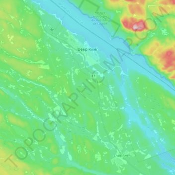
Nome: Mapa topográfico Deep River, altitude, relevo.
Altitude média: 169 m
Altitude mínima: 103 m
Altitude máxima: 411 m
Faça uma doação
Outros mapas topográficos
Clique em um mapa para visualizar sua topografia, sua altitude e seu relevo.
Foymount
Canada > Ontario > Renfrew County > Bonnechere Valley
The location is also popular for amateur astronomers given the high altitude and low levels of artificial light.
Altitude média: 432 m
Faça uma doação
Faça uma doação
Faça uma doação
Faça uma doação
Madawaska River
Canada > Ontario > Renfrew County > Greater Madawaska > Calabogie
Altitude média: 160 m
Faça uma doação
Faça uma doação
Faça uma doação
Faça uma doação
Faça uma doação
Faça uma doação
Faça uma doação
Mount St. Patrick Mountains
Canada > Ontario > Renfrew County > Greater Madawaska
Altitude média: 390 m
Madawaska Highlands
Canada > Ontario > Renfrew County > Killaloe, Hagarty and Richards
Altitude média: 272 m
Faça uma doação
Faça uma doação
Faça uma doação