
Faça uma doação
Mapa topográfico Skardu
Clique no mapa para exibir a altitude.
Faça uma doação
Skardu
Skardu (Balti: སྐར་མདོ་་; Urdu: سکردو, romanized: skardū, pronounced [skərduː]) is a city located in Pakistani-administered Gilgit−Baltistan in the disputed Kashmir region. Skardu serves as the capital of Skardu District and the Baltistan Division. It is situated at an average elevation of nearly 2,500 metres (8,202 feet) above sea level in the Skardu Valley, at the confluence of the Indus and Shigar Rivers. The city is an important gateway to the eight-thousanders of the nearby Karakoram mountain range. The Indus River running through the region separates the Karakoram from the Ladakh Range.
Faça uma doação
Sobre este mapa
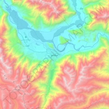
Nome: Mapa topográfico Skardu, altitude, relevo.
Altitude média: 3.423 m
Altitude mínima: 2.169 m
Altitude máxima: 5.312 m
Faça uma doação
Outros mapas topográficos
Clique em um mapa para visualizar sua topografia, sua altitude e seu relevo.