
Mapa topográfico Littlemore
Mapa interativo
Clique no mapa para exibir a altitude.
Sobre este mapa
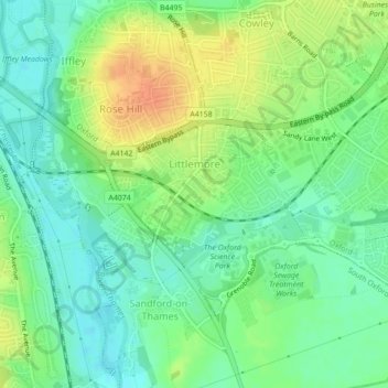
Nome: Mapa topográfico Littlemore, altitude, relevo.
Local: Littlemore, Oxford, Oxfordshire, England, United Kingdom (51.71098 -1.23404 51.72789 -1.20642)
Altitude média: 67 m
Altitude mínima: 50 m
Altitude máxima: 91 m
Outros mapas topográficos
Clique em um mapa para visualizar sua topografia, sua altitude e seu relevo.
Botley Stream
United Kingdom > England > Oxfordshire > Oxford
Botley Stream, New Botley, West Oxford, Oxford, Oxfordshire, England, OX2 0ED, United Kingdom
Altitude média: 67 m
Binsey
United Kingdom > England > Oxfordshire > Oxford
Binsey, Oxford, Oxfordshire, England, OX2 0NG, United Kingdom
Altitude média: 64 m
Oxford
United Kingdom > England > Oxfordshire > Oxford
Oxford, Oxfordshire, South East England, England, OX1 3HY, United Kingdom
Altitude média: 81 m
The Triangle
United Kingdom > England > Oxfordshire > Oxford
The Triangle, Iffley, Oxford, Oxfordshire, South East England, England, United Kingdom
Altitude média: 63 m
Marston
United Kingdom > England > Oxfordshire > Oxford
Marston, Oxford, Oxfordshire, England, OX3 0PX, United Kingdom
Altitude média: 71 m