
Mapa topográfico Hathersage
Clique no mapa para exibir a altitude.
Hathersage
The Fat Boys Stanage Struggle is a popular local fell race that starts in Hathersage, altitude 91 metres (299 ft), and routes up to and along Stanage Edge to High Neb, 458 metres (1,503 ft), before returning to the village 367 metres (1,204 ft) below.
Sobre este mapa
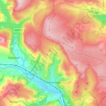
Nome: Mapa topográfico Hathersage, altitude, relevo.
Altitude média: 311 m
Altitude mínima: 136 m
Altitude máxima: 462 m
Outros mapas topográficos
Clique em um mapa para visualizar sua topografia, sua altitude e seu relevo.
Hallam Moors
United Kingdom > England > Derbyshire > Derbyshire Dales > Hathersage
Altitude média: 368 m
Slaley
United Kingdom > England > Derbyshire > Derbyshire Dales > Matlock > Bonsall CP
Altitude média: 263 m
Bolehill
United Kingdom > England > Derbyshire > Derbyshire Dales > Wirksworth CP
Altitude média: 220 m
Riber Castle
United Kingdom > England > Derbyshire > Derbyshire Dales > Matlock > Starkholmes
Altitude média: 169 m
Monsal Head
United Kingdom > England > Derbyshire > Derbyshire Dales > Cressbrook > Monsal Head
Altitude média: 231 m
Parsley Hay
United Kingdom > England > Derbyshire > Derbyshire Dales > Parsley Hay
Altitude média: 334 m
Arbor Low
United Kingdom > England > Derbyshire > Derbyshire Dales > Parsley Hay
Altitude média: 342 m
Two Dales
United Kingdom > England > Derbyshire > Derbyshire Dales > Darley Dale CP > Darley Hillside
Altitude média: 189 m
Magpie Mine
United Kingdom > England > Derbyshire > Derbyshire Dales > Ashford in the Water CP
Altitude média: 303 m
Catcliff Wood
United Kingdom > England > Derbyshire > Derbyshire Dales > Bakewell CP
Altitude média: 173 m
Gang Mine
United Kingdom > England > Derbyshire > Derbyshire Dales > Cromford CP
Altitude média: 226 m
Taddington Dale
United Kingdom > England > Derbyshire > Derbyshire Dales > Brushfield CP
Altitude média: 281 m
Cressbrook Dale
United Kingdom > England > Derbyshire > Derbyshire Dales > Litton CP > Litton Mill
Altitude média: 286 m
Curbar Edge
United Kingdom > England > Derbyshire > Derbyshire Dales > Curbar CP
Altitude média: 252 m
Hathersage Booths
United Kingdom > England > Derbyshire > Derbyshire Dales > Hathersage
Altitude média: 260 m
Stanage Plantation
United Kingdom > England > Derbyshire > Derbyshire Dales > Hathersage
Altitude média: 360 m
Black Rocks
United Kingdom > England > Derbyshire > Derbyshire Dales > Cromford CP
Altitude média: 199 m
Padley Gorge
United Kingdom > England > Derbyshire > Derbyshire Dales > Grindleford
Altitude média: 316 m
Horseshoe Quarry
United Kingdom > England > Derbyshire > Derbyshire Dales > Eyam CP
Altitude média: 293 m
Curbar Edge
United Kingdom > England > Derbyshire > Derbyshire Dales > Calver Sough
Altitude média: 251 m
Calver Sough
United Kingdom > England > Derbyshire > Derbyshire Dales > Calver Sough
Altitude média: 218 m
Breamfield
United Kingdom > England > Derbyshire > Derbyshire Dales > Wirksworth CP > Breamfield
Altitude média: 213 m
Coplow Dale
United Kingdom > England > Derbyshire > Derbyshire Dales > Little Hucklow
Altitude média: 333 m
Stoke Brook
United Kingdom > England > Derbyshire > Derbyshire Dales > Calver Sough
Altitude média: 197 m
Longstone Edge
United Kingdom > England > Derbyshire > Derbyshire Dales > Rowland
Altitude média: 290 m
Longcliffe
United Kingdom > England > Derbyshire > Derbyshire Dales > Brassington CP
Altitude média: 299 m
Lathkill Dale
United Kingdom > England > Derbyshire > Derbyshire Dales > Youlgreave
Altitude média: 269 m
Yarncliff Wood
United Kingdom > England > Derbyshire > Derbyshire Dales > Grindleford
Altitude média: 260 m
Breamfield
United Kingdom > England > Derbyshire > Derbyshire Dales > Wirksworth CP
Altitude média: 213 m
Padley Gorge
United Kingdom > England > Derbyshire > Derbyshire Dales > Grindleford
Altitude média: 316 m
Wirksworth Moor
United Kingdom > England > Derbyshire > Derbyshire Dales > Wirksworth CP
Altitude média: 207 m