
Faça uma doação
Mapa topográfico Huasca de Ocampo
Clique no mapa para exibir a altitude.
Faça uma doação
Huasca de Ocampo
The municipality extends from the Sierra de Pachuca mountains, where the town is, to over part of a wide, flat valley with lower altitude and warmer temperatures. This area is filled with small towns and villages, as well as fields and orchards. The higher elevations around these flat lands are forested with holm oak which give them an ashy-green look. The altitude of the municipality varies from between 1,800 and 2,800 masl. The municipality is part of the Reserva de la Biosfera de la Vega de Meztitlán (Vega de Meztitlán Biosphere Reserve). About 70% of the municipality lies on the Trans-Mexican Volcanic Belt although there are no active volcanoes here.
Faça uma doação
Sobre este mapa
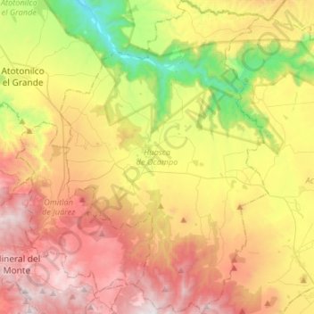
Nome: Mapa topográfico Huasca de Ocampo, altitude, relevo.
Local: Huasca de Ocampo, Hidalgo, Mexico (20.09931 -98.63741 20.34703 -98.46145)
Altitude média: 2.208 m
Altitude mínima: 1.424 m
Altitude máxima: 3.063 m
Faça uma doação
Outros mapas topográficos
Clique em um mapa para visualizar sua topografia, sua altitude e seu relevo.
Faça uma doação
Faça uma doação
Faça uma doação
Faça uma doação
Faça uma doação