
Mapa topográfico Löllbach
Mapa interativo
Clique no mapa para exibir a altitude.
Sobre este mapa
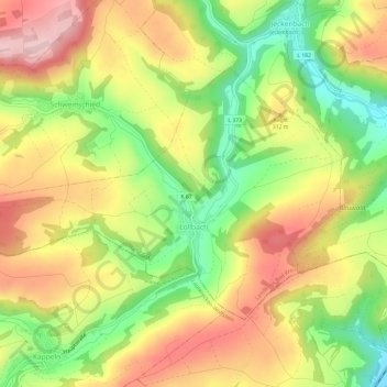
Nome: Mapa topográfico Löllbach, altitude, relevo.
Altitude média: 279 m
Altitude mínima: 156 m
Altitude máxima: 398 m
Löllbach is a typical clump village and lies between Lauterecken and Meisenheim, off the major traffic routes, in the North Palatine Uplands at an elevation of 208 m (682 ft) above mean sea level. Running through the village is the Jeckenbach, and emptying into it in the village core is the Schweinschieder Bach. The municipal area measures 494 hectares (1,220 acres).