
Faça uma doação
Mapa topográfico Rodon
Clique no mapa para exibir a altitude.
Faça uma doação
Sobre este mapa
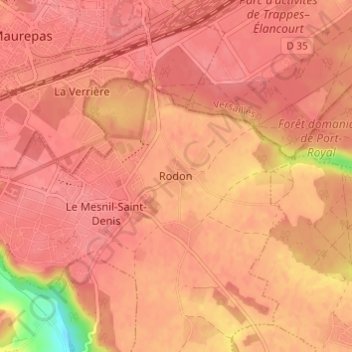
Nome: Mapa topográfico Rodon, altitude, relevo.
Altitude média: 167 m
Altitude mínima: 112 m
Altitude máxima: 179 m
Faça uma doação
Outros mapas topográficos
Clique em um mapa para visualizar sua topografia, sua altitude e seu relevo.
Versailles
France > Ile-de-France > Yvelines
Versailles is located 17.1 km (10.6 mi) west-southwest from the centre of Paris. The city sits on an elevated plateau, 130 to 140 metres (425 to 460 ft) above sea-level (whereas the elevation of the centre of Paris is only 33 m (108 ft) above sea level), surrounded by wooded hills: in the north the forests of…
Altitude média: 142 m
Faça uma doação
Versailles
France > Ile-de-France > Yvelines
Versailles is located 17.1 km (10.6 mi) west-southwest from the centre of Paris. The city sits on an elevated plateau, 130 to 140 metres (430 to 460 ft) above sea level (whereas the elevation of the centre of Paris is only 33 m (108 ft) above sea level), surrounded by wooded hills: in the north the forests of…
Altitude média: 142 m
Faça uma doação
Montfort-l'Amaury
France > Ile-de-France > Yvelines
Montfort-l'Amaury lies north of the Rambouillet Forest. It is located at the foot of low hills, at about 130 m above sea level. Montfort-l’Amaury has a land area of about 5.71 km², with an elevation of approximately 130 meters above sea level. As of the latest legal census, the population is around 2,790…
Altitude média: 152 m
Faça uma doação
Versailles
France > Ile-de-France > Yvelines
Versailles is located 17.1 km (10.6 mi) west-southwest from the centre of Paris. The city sits on an elevated plateau, 130 to 140 metres (430 to 460 ft) above sea level (whereas the elevation of the centre of Paris is only 33 m (108 ft) above sea level), surrounded by wooded hills: in the north the forests of…
Altitude média: 142 m
Faça uma doação
Faça uma doação
Le Vésinet
France > Ile-de-France > Yvelines
The terrain is an alluvial plain ranging in altitude from 28 meters near Le Pecq to 45 meters at the end of the Route de Montesson, with a gentle slope from northeast to southwest.
Altitude média: 37 m
Versailles
France > Ile-de-France > Yvelines
Versailles is located 17.1 km (10.6 mi) west-southwest from the centre of Paris. The city sits on an elevated plateau, 130 to 140 metres (430 to 460 ft) above sea level (whereas the elevation of the centre of Paris is only 33 m (108 ft) above sea level), surrounded by wooded hills: in the north the forests of…
Altitude média: 142 m
Faça uma doação
Faça uma doação
Faça uma doação
Buc
France > Ile-de-France > Yvelines
The old town lies in the valley of the River Bièvre at an elevation of around 100 m above sea level. Most of Buc's residential districts have been built on the plateau de Saclay, some 50 m higher.
Altitude média: 151 m
Faça uma doação
Faça uma doação
Faça uma doação
Buc
France > Ile-de-France > Yvelines
The old town lies in the valley of the River Bièvre at an elevation of around 100 m above sea level. Most of Buc's residential districts have been built on the plateau de Saclay, some 50 m higher.
Altitude média: 151 m
Faça uma doação