
Obrigado por apoiar este site ❤️
Faça uma doação
Faça uma doação
Mapa topográfico Calbayog
Clique no mapa para exibir a altitude.
Obrigado por apoiar este site ❤️
Faça uma doação
Faça uma doação
Calbayog
Forty percent of the city's land area are plain and hilly terrains with elevation ranging from 5 to 20 metres (16 to 66 ft) above sea level. The rest are rugged mountain ranges with elevations from 300 to 700 metres (980 to 2,300 ft) above sea level. Flooding is minimized because of many rivers, brooks, streams and natural water conveyors that flow towards the sea.
Obrigado por apoiar este site ❤️
Faça uma doação
Faça uma doação
Sobre este mapa
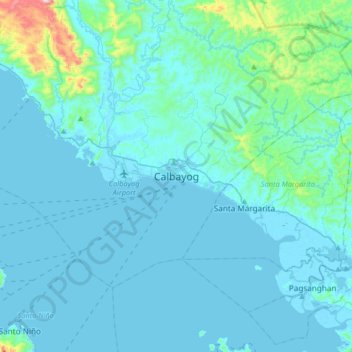
Nome: Mapa topográfico Calbayog, altitude, relevo.
Local: Calbayog, Samar, Eastern Visayas, 6710, Philippines (11.90696 124.43467 12.22696 124.75467)
Altitude média: 55 m
Altitude mínima: -2 m
Altitude máxima: 662 m
Obrigado por apoiar este site ❤️
Faça uma doação
Faça uma doação
Outros mapas topográficos
Clique em um mapa para visualizar sua topografia, sua altitude e seu relevo.