
Obrigado por apoiar este site ❤️
Faça uma doação
Faça uma doação
Mapa topográfico Aubeterre-sur-Dronne
Clique no mapa para exibir a altitude.
Obrigado por apoiar este site ❤️
Faça uma doação
Faça uma doação
Aubeterre-sur-Dronne
The highest point of the commune is at an altitude of 111m and is located on the plateau near the northern boundary. The lowest point is 38m located on the southern boundary next to the Dronne. The commune is spread between the valley of the Dronne and the top of the hill.
Obrigado por apoiar este site ❤️
Faça uma doação
Faça uma doação
Sobre este mapa
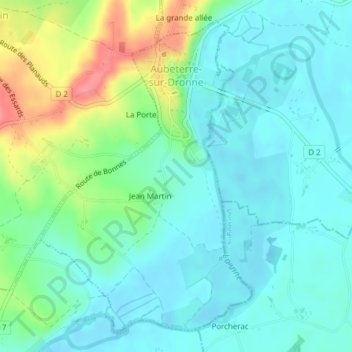
Nome: Mapa topográfico Aubeterre-sur-Dronne, altitude, relevo.
Altitude média: 60 m
Altitude mínima: 38 m
Altitude máxima: 119 m
Obrigado por apoiar este site ❤️
Faça uma doação
Faça uma doação
Outros mapas topográficos
Clique em um mapa para visualizar sua topografia, sua altitude e seu relevo.
Obrigado por apoiar este site ❤️
Faça uma doação
Faça uma doação
Obrigado por apoiar este site ❤️
Faça uma doação
Faça uma doação
Obrigado por apoiar este site ❤️
Faça uma doação
Faça uma doação
Obrigado por apoiar este site ❤️
Faça uma doação
Faça uma doação
Obrigado por apoiar este site ❤️
Faça uma doação
Faça uma doação