
Mapa topográfico Stoney Island
Mapa interativo
Clique no mapa para exibir a altitude.
Sobre este mapa
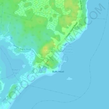
Nome: Mapa topográfico Stoney Island, altitude, relevo.
Altitude média: 3 m
Altitude mínima: -2 m
Altitude máxima: 17 m
Outros mapas topográficos
Clique em um mapa para visualizar sua topografia, sua altitude e seu relevo.
Goose Lake
Canada > Nova Scotia > Shelburne County
Goose Lake, Municipality of the District of Barrington, Shelburne County, Nova Scotia, B0W 1E0, Canada
Altitude média: 21 m
Town of Clark's Harbour
Canada > Nova Scotia > Shelburne County
Town of Clark's Harbour, Shelburne County, Nova Scotia, Canada
Altitude média: 2 m
Town of Shelburne
Canada > Nova Scotia > Shelburne County
Town of Shelburne, Shelburne County, Nova Scotia, Canada
Altitude média: 28 m
Canada Hill
Canada > Nova Scotia > Shelburne County > Canada Hill
Canada Hill, Municipality of the District of Shelburne, Shelburne County, Nova Scotia, B0T 1L0, Canada
Altitude média: 34 m
Churchover
Canada > Nova Scotia > Shelburne County
Churchover, Municipality of the District of Shelburne, Shelburne County, Nova Scotia, B0T 1W0, Canada
Altitude média: 27 m
Ingomar
Canada > Nova Scotia > Shelburne County
Ingomar, Municipality of the District of Shelburne, Shelburne County, Nova Scotia, B0T 1W0, Canada
Altitude média: 5 m
Shelburne
Canada > Nova Scotia > Shelburne County > Shelburne
Shelburne, Town of Shelburne, Shelburne County, Nova Scotia, Canada
Altitude média: 28 m