
Faça uma doação
Mapa topográfico Jose Rono
Clique no mapa para exibir a altitude.
Faça uma doação
Sobre este mapa
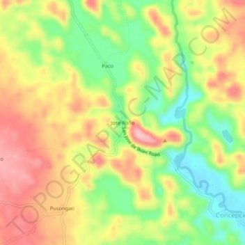
Nome: Mapa topográfico Jose Rono, altitude, relevo.
Local: Jose Rono, Samar, Eastern Visayas, 6723, Philippines (11.88295 125.02294 11.92295 125.06294)
Altitude média: 176 m
Altitude mínima: 84 m
Altitude máxima: 264 m
Faça uma doação
Outros mapas topográficos
Clique em um mapa para visualizar sua topografia, sua altitude e seu relevo.
Calbayog
Forty percent of the city's land area are plain and hilly terrains with elevation ranging from 5 to 20 metres (16 to 66 ft) above sea level. The rest are rugged mountain ranges with elevations from 300 to 700 metres (980 to 2,300 ft) above sea level. Flooding is minimized because of many rivers, brooks,…
Altitude média: 78 m
Faça uma doação
Faça uma doação
Faça uma doação
Faça uma doação
Faça uma doação
Silanga District of Catbalogan City
Philippines > Samar > Silanga District of Catbalogan City
Altitude média: 21 m
Faça uma doação
Calbayog
Forty percent of the city's land area are plain and hilly terrains with elevation ranging from 5 to 20 metres (16 to 66 ft) above sea level. The rest are rugged mountain ranges with elevations from 300 to 700 metres (980 to 2,300 ft) above sea level. Flooding is minimized because of many rivers, brooks,…
Altitude média: 78 m
Faça uma doação
Faça uma doação
Calbayog
Forty percent of the city's land area are plain and hilly terrains with elevation ranging from 5 to 20 metres (16 to 66 ft) above sea level. The rest are rugged mountain ranges with elevations from 300 to 700 metres (980 to 2,300 ft) above sea level. Flooding is minimized because of many rivers, brooks,…
Altitude média: 78 m