
Faça uma doação
Mapa topográfico Badung
Clique no mapa para exibir a altitude.
Faça uma doação
Badung
Topographically, Badung Regency has a variety of land surface contours. In the southern region, the dominant land surface contour is the lowlands to the coastal areas. Meanwhile, the central region is dominated by lowlands which are then followed by the land surface contours of hills and mountains in the northern region. The height of the land surface in Badung Regency varies between 0 and ±2000 meters above sea level. Based on its altitude, the districts of South Kuta, North Kuta, and Kuta are at an altitude of 0–65 meters above sea level, the Mengwi district is at an altitude of 0–350 meters above sea level, the Abiansemal district is at an altitude of 75–350 meters above sea level, and the Petang district is at an altitude of between 250 and 2075 meters above sea level.
Faça uma doação
Sobre este mapa
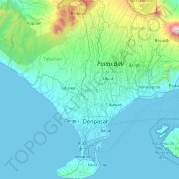
Nome: Mapa topográfico Badung, altitude, relevo.
Local: Badung, Bali, Lesser Sunda Islands, Indonesia (-9.05023 114.87055 -8.23944 115.34988)
Altitude média: 208 m
Altitude mínima: -1 m
Altitude máxima: 2.957 m
Faça uma doação
Outros mapas topográficos
Clique em um mapa para visualizar sua topografia, sua altitude e seu relevo.
Faça uma doação
Faça uma doação
CitraLand Waterpark Denpasar
Indonesia > Bali > Denpasar > Denpasar Barat > Padangsambian Kaja
Altitude média: 56 m
Faça uma doação
Faça uma doação
Faça uma doação
Faça uma doação
Faça uma doação
Faça uma doação
Faça uma doação
Faça uma doação
Faça uma doação
Faça uma doação
Faça uma doação
Faça uma doação
Faça uma doação
Point of view on the lake and the mount Batur
Indonesia > Bali > Bangli > Songan B
Altitude média: 1.059 m
Faça uma doação
Faça uma doação
Faça uma doação
Faça uma doação
Mount Agung
Indonesia > Bali > Karangasem
Australia's Bureau of Meteorology reported on 27 November that ash from the eruption had been observed at an altitude of 9,144 m. By the beginning of December, the eruption reduced to minor emissions of steam and smoke. On 12 December, a picture of the crater was taken showing a steadily growing lava dome…
Altitude média: 2.534 m
Faça uma doação
Faça uma doação
Faça uma doação
Faça uma doação
Faça uma doação
Faça uma doação