
Mapa topográfico Fayetteville
Mapa interativo
Clique no mapa para exibir a altitude.
Sobre este mapa
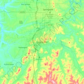
Nome: Mapa topográfico Fayetteville, altitude, relevo.
Altitude média: 404 m
Altitude mínima: 310 m
Altitude máxima: 674 m
...yet I venture the assertion that nowhere in said country—or for that matter, in any part of the state—could be found a lovelier elevation, or a lovelier grove of graceful oaks, or a more commanding view, or, in fine, a spot better suited and adapted for the purposes designated than the one chosen for said University site and farm.
Outros mapas topográficos
Clique em um mapa para visualizar sua topografia, sua altitude e seu relevo.
South Mountain
United States > Arkansas > Washington County > Fayetteville
South Mountain, Fayetteville, Washington County, Arkansas, 72701, United States
Altitude média: 405 m
Washington Mountain
United States > Arkansas > Washington County > Fayetteville
Washington Mountain, Fayetteville, Washington County, Arkansas, United States
Altitude média: 409 m