
Obrigado por apoiar este site ❤️
Faça uma doação
Faça uma doação
Mapa topográfico Grimwith Fell
Clique no mapa para exibir a altitude.
Obrigado por apoiar este site ❤️
Faça uma doação
Faça uma doação
Sobre este mapa
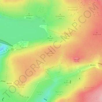
Nome: Mapa topográfico Grimwith Fell, altitude, relevo.
Altitude média: 328 m
Altitude mínima: 243 m
Altitude máxima: 402 m
Obrigado por apoiar este site ❤️
Faça uma doação
Faça uma doação
Outros mapas topográficos
Clique em um mapa para visualizar sua topografia, sua altitude e seu relevo.
Winterburn Beck
United Kingdom > England > North Yorkshire > Craven > Winterburn
Altitude média: 201 m