
Obrigado por apoiar este site ❤️
Faça uma doação
Faça uma doação
Mapa topográfico Alchi
Clique no mapa para exibir a altitude.
Obrigado por apoiar este site ❤️
Faça uma doação
Faça uma doação
Sobre este mapa
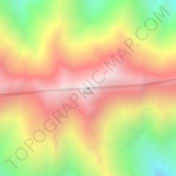
Nome: Mapa topográfico Alchi, altitude, relevo.
Local: Alchi, Leh Tehsil, Leh district, Ladakh, India (34.15834 77.25648 34.15844 77.25658)
Altitude média: 4.285 m
Altitude mínima: 3.555 m
Altitude máxima: 4.879 m
Obrigado por apoiar este site ❤️
Faça uma doação
Faça uma doação
Outros mapas topográficos
Clique em um mapa para visualizar sua topografia, sua altitude e seu relevo.
Indus
India > Ladakh > Leh Tehsil
In the uppermost, highest part of the Indus River basin there are relatively few genera and species: Diptychus, Ptychobarbus, Schizopyge, Schizopygopsis and Schizothorax snowtrout, Triplophysa loaches, and the catfish Glyptosternon reticulatum. Going downstream these are soon joined by the golden mahseer Tor…
Altitude média: 4.192 m