
Faça uma doação
Mapa topográfico Estes Park
Clique no mapa para exibir a altitude.
Faça uma doação
Estes Park
Estes Park sits at an elevation of 7,522 feet (2,293 m) on the front range of the Rocky Mountains at the eastern entrance of the Rocky Mountain National Park. Its location is 40°22′22″N 105°31′09″W / 40.372856°N 105.519136°W / 40.372856; -105.519136. Its north, south and east extremities border the Roosevelt National Forest. Lumpy Ridge lies immediately north of Estes Park.
Faça uma doação
Sobre este mapa
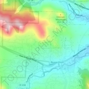
Nome: Mapa topográfico Estes Park, altitude, relevo.
Local: Estes Park, Larimer County, Colorado, United States (40.36869 -105.55213 40.37091 -105.54714)
Altitude média: 2.409 m
Altitude mínima: 2.310 m
Altitude máxima: 2.636 m
Faça uma doação
Outros mapas topográficos
Clique em um mapa para visualizar sua topografia, sua altitude e seu relevo.
Fort Collins
United States > Colorado > Larimer County
Fort Collins is situated at the base of the Rocky Mountain foothills of the northern Front Range, approximately 60 miles (97 km) north of Denver, Colorado, and 45 miles (72 km) south of Cheyenne, Wyoming. Elevation is 4,982 ft (1,519 m) above sea level. Geographic landmarks include Horsetooth Reservoir and…
Altitude média: 1.560 m
Estes Park
United States > Colorado > Larimer County
Estes Park sits at an elevation of 7,522 feet (2,293 m) on the front range of the Rocky Mountains at the eastern entrance of the Rocky Mountain National Park. Its north, south and east extremities border the Roosevelt National Forest. Lumpy Ridge lies immediately north of Estes Park.
Altitude média: 2.430 m
Faça uma doação