
Mapa topográfico Forchheim
Mapa interativo
Clique no mapa para exibir a altitude.
Sobre este mapa
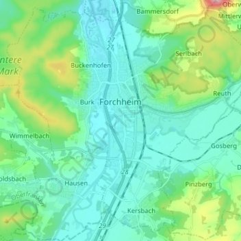
Nome: Mapa topográfico Forchheim, altitude, relevo.
Local: Forchheim, Landkreis Forchheim, Bavaria, 91301, Germany (49.67385 10.99958 49.75090 11.12663)
Altitude média: 299 m
Altitude mínima: 250 m
Altitude máxima: 493 m
Forchheim (German pronunciation: [ˈfɔʁçhaɪ̯m] (listen)) is a town in Upper Franconia (German: Oberfranken) in northern Bavaria, and also the seat of the administrative district of Forchheim. Forchheim is a former royal city, and is sometimes called the Gateway to the Franconian Switzerland, referring to the region of outstanding natural beauty to the north east of the town. Nowadays Forchheim is most famous for its ten day long beer and music festival (Annafest) which takes place in late July in an idyllic wooded hillside, home to 24 beer gardens, on the outskirts of the town. Forchheim's population, as of December 2013, was 30,705, and its land area is 44.95 square kilometres (17.36 square miles). Its position is 49° 44' N, 11° 04' E and its elevation is 265 metres (869 feet) above sea level.
Outros mapas topográficos
Clique em um mapa para visualizar sua topografia, sua altitude e seu relevo.
Trainmeusel
Germany > Bavaria > Landkreis Forchheim > Wiesenttal
Trainmeusel, Wiesenttal, Landkreis Forchheim, Bavaria, 91346, Germany
Altitude média: 433 m
Ebermannstadt
Germany > Bavaria > Landkreis Forchheim > Ebermannstadt > Ebermannstadt
Ebermannstadt, Ebermannstadt (VGem), Landkreis Forchheim, Bavaria, 91320, Germany
Altitude média: 408 m
Leutenbach
Germany > Bavaria > Landkreis Forchheim
Leutenbach, Kirchehrenbach (VGem), Landkreis Forchheim, Bavaria, 91359, Germany
Altitude média: 410 m