
Faça uma doação
Mapa topográfico Trout Creek
Clique no mapa para exibir a altitude.
Faça uma doação
Sobre este mapa
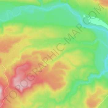
Nome: Mapa topográfico Trout Creek, altitude, relevo.
Local: Trout Creek, Clearwater County, Alberta, Canada (52.39377 -115.63196 52.42132 -115.47749)
Altitude média: 1.205 m
Altitude mínima: 1.057 m
Altitude máxima: 1.439 m
Faça uma doação
Outros mapas topográficos
Clique em um mapa para visualizar sua topografia, sua altitude e seu relevo.
Nordegg
Canada > Alberta > Clearwater County
Nordegg has a subarctic climate (Dfc) which can be considered a subalpine climate due to its altitude with locations on the same latitude having warmer climates. Summers are mild, with a few warm days sprinkled in here and there, while winters are cold and snowy.
Altitude média: 1.475 m
Cutoff Creek Equestrian Staging Public Land Recreation Area
Canada > Alberta > Clearwater County
Altitude média: 1.509 m
Faça uma doação
Faça uma doação
Faça uma doação
Nordegg
Canada > Alberta > Clearwater County
Nordegg has a subarctic climate (Dfc) which can be considered a subalpine climate due to its altitude with locations on the same latitude having warmer climates. Summers are mild, with a few warm days sprinkled in here and there, while winters are cold and snowy.
Altitude média: 1.475 m
Nordegg
Canada > Alberta > Clearwater County
Nordegg has a subarctic climate (Dfc) which can be considered a subalpine climate due to its altitude with locations on the same latitude having warmer climates. Summers are mild, with a few warm days sprinkled in here and there, while winters are cold and snowy.
Altitude média: 1.399 m
Faça uma doação