
Mapa topográfico Royal Pines
Mapa interativo
Clique no mapa para exibir a altitude.
Sobre este mapa
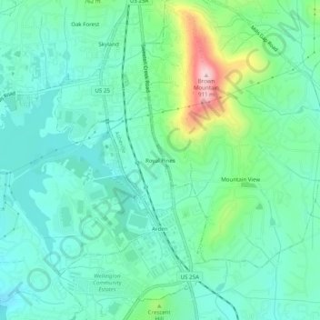
Nome: Mapa topográfico Royal Pines, altitude, relevo.
Altitude média: 700 m
Altitude mínima: 637 m
Altitude máxima: 903 m
Royal Pines is located in southern Buncombe County at 35°28′39″N 82°30′35″W / 35.47750°N 82.50972°W / 35.47750; -82.50972 (35.477386, -82.509833). It is bordered to the west by U.S. Route 25A and the city limits of Asheville, and to the northeast by Mills Gap Road. Brown Mountain, with an elevation of 2,996 feet (913 m), occupies the center of the CDP.
Outros mapas topográficos
Clique em um mapa para visualizar sua topografia, sua altitude e seu relevo.
Biltmore Village
United States > North Carolina > Buncombe County > Asheville
Biltmore Village, Asheville, Buncombe County, North Carolina, 28802, United States
Altitude média: 642 m
Albemarle
United States > North Carolina > Buncombe County > Asheville
Albemarle, Asheville, Buncombe County, North Carolina, 28802, United States
Altitude média: 718 m
Biltmore
United States > North Carolina > Buncombe County > Asheville
Biltmore, Asheville, Buncombe County, North Carolina, 28803, United States
Altitude média: 650 m
Redwood Village
United States > North Carolina > Buncombe County > Asheville
Redwood Village, Asheville, Buncombe County, North Carolina, 28805, United States
Altitude média: 657 m
Aston Park
United States > North Carolina > Buncombe County > Asheville > River Arts District
Aston Park, River Arts District, Asheville, Buncombe County, North Carolina, 28801, United States
Altitude média: 641 m
Kenilworth
United States > North Carolina > Buncombe County > Asheville
Kenilworth, Asheville, Buncombe County, North Carolina, 28802, United States
Altitude média: 648 m
Deaver View
United States > North Carolina > Buncombe County > Asheville
Deaver View, Asheville, Buncombe County, North Carolina, 28806, United States
Altitude média: 678 m