
Mapa topográfico Kastenfeld
Mapa interativo
Clique no mapa para exibir a altitude.
Sobre este mapa
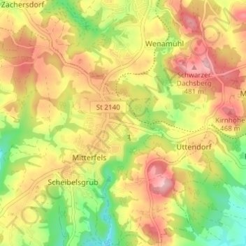
Nome: Mapa topográfico Kastenfeld, altitude, relevo.
Altitude média: 416 m
Altitude mínima: 332 m
Altitude máxima: 489 m
Outros mapas topográficos
Clique em um mapa para visualizar sua topografia, sua altitude e seu relevo.
Talmühle
Deutschland > Bayern > Landkreis Straubing-Bogen > Scheibelsgrub > Talmühle
Talmühle, Scheibelsgrub, Mitterfels, Mitterfels (VGem), Landkreis Straubing-Bogen, Bayern, 94360, Deutschland
Altitude média: 408 m