
Mapa topográfico Tynda
Mapa interativo
Clique no mapa para exibir a altitude.
Sobre este mapa
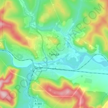
Nome: Mapa topográfico Tynda, altitude, relevo.
Altitude média: 566 m
Altitude mínima: 477 m
Altitude máxima: 766 m
The town is located at an elevation of 500 meters (1,600 ft) above sea level, near where the Getkan joins the Tynda River, after which the town was named. The Tynda then flows into the Gilyuy, a tributary of the Zeya, a few kilometers east of the town.