
Mapa topográfico Dohan
Mapa interativo
Clique no mapa para exibir a altitude.
Sobre este mapa
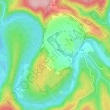
Nome: Mapa topográfico Dohan, altitude, relevo.
Local: Dohan, Bouillon, Neufchâteau, Luxembourg, Wallonie, Belgique (49.77870 5.11528 49.80675 5.16091)
Altitude média: 284 m
Altitude mínima: 220 m
Altitude máxima: 400 m
Outros mapas topográficos
Clique em um mapa para visualizar sua topografia, sua altitude e seu relevo.
Château des Amerois
Belgique > Luxembourg > Neufchâteau > Bouillon
Château des Amerois, Les Amerois, Bouillon, Neufchâteau, Luxembourg, Wallonie, 6830, Belgique
Altitude média: 401 m
Frahan
Belgique > Luxembourg > Neufchâteau > Bouillon
Frahan, Rochehaut, Bouillon, Neufchâteau, Luxembourg, Wallonie, 6838, Belgique
Altitude média: 291 m
Botassart
Belgique > Luxembourg > Neufchâteau > Bouillon > Ucimont
Botassart, Ucimont, Bouillon, Neufchâteau, Luxembourg, Wallonie, 6833, Belgique
Altitude média: 319 m
Rochehaut
Belgique > Luxembourg > Neufchâteau > Bouillon
Rochehaut, Bouillon, Neufchâteau, Luxembourg, Wallonie, Belgique
Altitude média: 298 m
Corbion
Belgique > Luxembourg > Neufchâteau > Bouillon
Corbion, Bouillon, Neufchâteau, Luxembourg, Wallonie, 6838, Belgique
Altitude média: 344 m
Bouillon
Belgique > Luxembourg > Neufchâteau > Bouillon
Bouillon, Neufchâteau, Luxembourg, Wallonie, 6830, Belgique
Altitude média: 338 m
Sensenruth
Belgique > Luxembourg > Neufchâteau > Bouillon
Sensenruth, Bouillon, Neufchâteau, Luxembourg, Wallonie, 6832, Belgique
Altitude média: 359 m
Poupehan
Belgique > Luxembourg > Neufchâteau > Bouillon
Poupehan, Bouillon, Neufchâteau, Luxembourg, Wallonie, Belgique
Altitude média: 270 m
Cordemois
Belgique > Luxembourg > Neufchâteau > Bouillon
Cordemois, Bouillon, Neufchâteau, Luxembourg, Wallonie, 6830, Belgique
Altitude média: 312 m