
Mapa topográfico Kopparberg
Mapa interativo
Clique no mapa para exibir a altitude.
Sobre este mapa
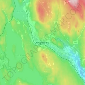
Nome: Mapa topográfico Kopparberg, altitude, relevo.
Altitude média: 196 m
Altitude mínima: 106 m
Altitude máxima: 380 m
Although Kopparberg is slightly further south, it is located at a slightly higher elevation 6 kilometres (3.7 mi) south-east, rendering likely values very similar. Winter highs usually average just below freezing, and frosts are frequent from October through April. Summers are very tempered, compared to both the Mälar Valley to the south and east and central Dalarna to the north. The warmest recorded temperature of 34.2 °C (93.6 °F) is still high by Swedish standards, courtesy of the unpredictability of its far inland position.
Outros mapas topográficos
Clique em um mapa para visualizar sua topografia, sua altitude e seu relevo.
Lekhyttan
Lekhyttan, Lekebergs kommun, Örebro County, 719 93, Sweden
Altitude média: 144 m
Gusselby
Gusselby, Lindesbergs kommun, Örebro County, 711 32, Sweden
Altitude média: 87 m
Malingsbo-Kloten
Malingsbo-Kloten, Lindesbergs kommun, Örebro County, Sweden
Altitude média: 274 m
Zinkgruvan
Zinkgruvan, Askersunds kommun, Örebro County, Sweden
Altitude média: 184 m
Hörksälv
Hörksälv, Ljusnarsbergs kommun, Örebro County, 772 94, Sweden
Altitude média: 272 m
Ställberg
Ställberg, Ljusnarsbergs kommun, Örebro County, 714 72, Sweden
Altitude média: 249 m
Blixterboda
Blixterboda, Lindesbergs kommun, Örebro County, 718 91, Sweden
Altitude média: 50 m
Brotorp
Brotorp, Lekebergs kommun, Örebro County, 716 31, Sweden
Altitude média: 75 m
Örebro
Örebro, Örebro kommun, Örebro County, 703 61, Sweden
Altitude média: 59 m
Rånnesta
Sweden > Örebro County > Örebro
Rånnesta, Örebro, Örebro kommun, Örebro County, 705 92, Sweden
Altitude média: 52 m
Lindesbergs kommun
Lindesbergs kommun, Örebro County, Sweden
Altitude média: 151 m
Frövi
Frövi, Lindesbergs kommun, Örebro County, 718 92, Sweden
Altitude média: 43 m