
Mapa topográfico Mount Erciyes
Mapa interativo
Clique no mapa para exibir a altitude.
Sobre este mapa
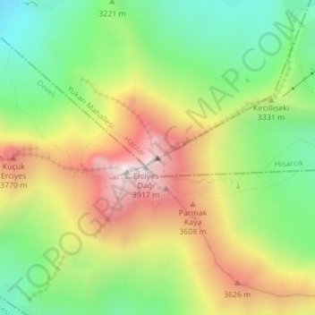
Nome: Mapa topográfico Mount Erciyes, altitude, relevo.
Altitude média: 3.329 m
Altitude mínima: 2.878 m
Altitude máxima: 3.896 m
The climate of the region is influenced by topography, with the Taurus and Kaçkar Mountains blocking the entry of moisture into Anatolia. Summers are dry and hot and winters wet and cold; in Kayseri, summer temperatures are about 19 °C (66 °F) and winter temperature about 0 °C (32 °F). Precipitation at Kayseri falls mostly in autumn, winter, and spring and amounts to 383 millimetres (15.1 in) per year. In Develi, south of Erciyes, maximum temperatures are about 29.5 °C (85.1 °F) and minimum temperatures −5.6 °C (21.9 °F). Estimated temperatures at 2,700 metres (8,900 ft) altitude are about −0.4 °C (31.3 °F), and precipitation 722 millimetres (28.4 in) per year. During the last glacial maximum, precipitation may have been double that of present-day.