
Mapa topográfico Oder
Mapa interativo
Clique no mapa para exibir a altitude.
Sobre este mapa
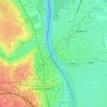
Nome: Mapa topográfico Oder, altitude, relevo.
Local: Oder, Frankfurt (Oder), Brandenburg, 15230, Germany (52.34574 14.55252 52.35444 14.55766)
Altitude média: 32 m
Altitude mínima: 10 m
Altitude máxima: 64 m
Outros mapas topográficos
Clique em um mapa para visualizar sua topografia, sua altitude e seu relevo.
Güldendorf
Germany > Brandenburg > Frankfurt (Oder) > Obermühle
Güldendorf, Obermühle, Frankfurt (Oder), Brandenburg, 15232, Germany
Altitude média: 51 m