
Mapa topográfico Westport
Clique no mapa para exibir a altitude.
Westport
The first clear evidence for the development of the new town is in an advertisement in Faulkner's Dublin Journal on March 17, 1767, stating 'a New Town is immediately to be built near the old town of Westport...according to Plans and Elevations already prepared'. The focal point was to be a 'large and elegant market house' situated in an octagonal market area enclosed by 12 'large well-finished slated Houses. There were to be 'three avenues for streets of thirty slated Houses' and 'several very large streets for great numbers of thatched Houses and cabbins, to be built separately' at a cost of 20-40 guineas each. Workmen were to contact Peter Brown-Kelly, son of the Earl or the architect William Leeson Westport is designated as a heritage town and is unusual in Ireland in that it is one of only a few planned towns in the country. Unfortunately, the original plans for the town are not available.
Sobre este mapa
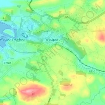
Nome: Mapa topográfico Westport, altitude, relevo.
Local: Westport, County Mayo, Connacht, Ireland (53.77863 -9.56868 53.81099 -9.49792)
Altitude média: 44 m
Altitude mínima: -1 m
Altitude máxima: 130 m
Outros mapas topográficos
Clique em um mapa para visualizar sua topografia, sua altitude e seu relevo.
Nephin
In Leabhar Fiachrach, a topographical and genealogical tract written by Giolla Iosa Mor Mac Fhirbhisigh about 1400, the areas early peoples and families are listed thus.
Altitude média: 404 m