
Faça uma doação
Mapa topográfico Newmarket
Clique no mapa para exibir a altitude.
Faça uma doação
Newmarket
Newmarket's geographical coordinates are 44.05°N, 79.46°W, and its elevation above sea level is 252 m. It has an area of 38.33 km². The town is bounded on the south by Aurora, on the west by King, on the north by East Gwillimbury and on the east by Whitchurch–Stouffville.
Faça uma doação
Sobre este mapa
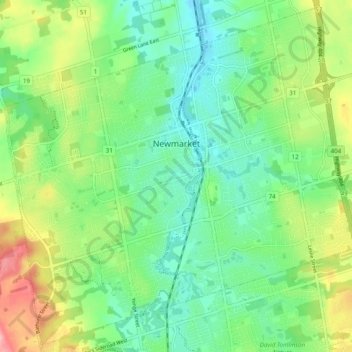
Nome: Mapa topográfico Newmarket, altitude, relevo.
Local: Newmarket, York Region, Golden Horseshoe, Ontario, Canada (44.01606 -79.50937 44.08345 -79.41174)
Altitude média: 270 m
Altitude mínima: 230 m
Altitude máxima: 349 m
Faça uma doação
Outros mapas topográficos
Clique em um mapa para visualizar sua topografia, sua altitude e seu relevo.
Faça uma doação
Faça uma doação
Keswick
Canada > Ontario > York Region
Keswick's geographical coordinates are 44.22°N, 79.45°W, and its elevation above sea level is 221m/762 ft. It has a geographical area of 16.25 km² according to Statistics Canada. It is bound on the north by Roches Point, the east by Woodbine Avenue, the south by East Gwillimbury (Ravenshoe Road) and the…
Altitude média: 228 m
Faça uma doação
Faça uma doação
Faça uma doação
Faça uma doação
Faça uma doação
Whitchurch-Stouffville Community Park, Vandorf
Canada > Ontario > York Region > Whitchurch-Stouffville
Altitude média: 305 m
Faça uma doação
Faça uma doação
East Holland River
Canada > Ontario > York Region > East Gwillimbury > Holland Landing
Altitude média: 223 m
Faça uma doação
Faça uma doação
Keswick
Canada > Ontario > York Region
Keswick's geographical coordinates are 44.22°N, 79.45°W, and its elevation above sea level is 221m/762 ft. It has a geographical area of 16.25 km² according to Statistics Canada. It is bound on the north by Roches Point, the east by Woodbine Avenue, the south by East Gwillimbury (Ravenshoe Road) and the…
Altitude média: 228 m
Faça uma doação