
Mapa topográfico Cittanova
Clique no mapa para exibir a altitude.
Cittanova
The altitude referring to the town hall building is 400 meters above mean sea level, in the municipal area the minimum altitude reaches 77 m above mean sea level while the maximum reaches 996 meters. The surface is 61.98 km² (about 65% in flat land planted with olive trees and 35% in mountainous wooded land and natural pastures).
Sobre este mapa
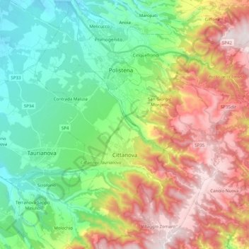
Nome: Mapa topográfico Cittanova, altitude, relevo.
Local: Cittanova, Reggio Calabria, Calabria, 89022, Italy (38.29537 16.00404 38.45003 16.14346)
Altitude média: 436 m
Altitude mínima: 76 m
Altitude máxima: 1.007 m
Outros mapas topográficos
Clique em um mapa para visualizar sua topografia, sua altitude e seu relevo.