
Obrigado por apoiar este site ❤️
Faça uma doação
Faça uma doação
Mapa topográfico Biescas
Clique no mapa para exibir a altitude.
Obrigado por apoiar este site ❤️
Faça uma doação
Faça uma doação
Biescas
The town of Biescas is located at 875 meters altitude on the banks of the Gállego river. The municipality extends along a small plain and includes the canyon to access to the Tena Valley. At 72 km north of the main city Huesca, Biescas is a communication hub between the regions of Jacetania and Sobrarbe. The town is strategically located to crossing the Gállego river, as a link between the valleys of Tena and Ara.
Obrigado por apoiar este site ❤️
Faça uma doação
Faça uma doação
Sobre este mapa
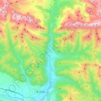
Nome: Mapa topográfico Biescas, altitude, relevo.
Local: Biescas, Alto Gállego, Huesca, Aragon, Spain (42.52936 -0.43230 42.72723 -0.21201)
Altitude média: 1.472 m
Altitude mínima: 775 m
Altitude máxima: 2.826 m
Obrigado por apoiar este site ❤️
Faça uma doação
Faça uma doação
Outros mapas topográficos
Clique em um mapa para visualizar sua topografia, sua altitude e seu relevo.