
Obrigado por apoiar este site ❤️
Faça uma doação
Faça uma doação
Mapa topográfico Bridge Gardens
Clique no mapa para exibir a altitude.
Obrigado por apoiar este site ❤️
Faça uma doação
Faça uma doação
Sobre este mapa
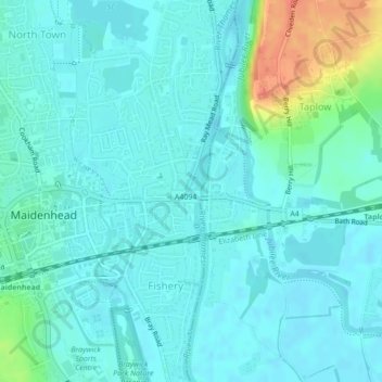
Nome: Mapa topográfico Bridge Gardens, altitude, relevo.
Altitude média: 30 m
Altitude mínima: 20 m
Altitude máxima: 70 m
Obrigado por apoiar este site ❤️
Faça uma doação
Faça uma doação
Outros mapas topográficos
Clique em um mapa para visualizar sua topografia, sua altitude e seu relevo.
Cox Green
United Kingdom > England > Royal Borough of Windsor and Maidenhead > Maidenhead
Altitude média: 36 m