
Faça uma doação
Mapa topográfico Walden
Clique no mapa para exibir a altitude.
Faça uma doação
Walden
Walden is the Statutory Town that is the county seat, the most populous community, and the only incorporated municipality in Jackson County, Colorado, United States. It is situated in the center of a large open valley called North Park. People from Walden and the surrounding area refer to themselves as "North Parkers". The town population was 606 at the 2020 census. The town sits at an elevation of 8,099 feet (2,469 meters). It was established in 1889 and was incorporated 2 December 1890. Mark A. Walden, an early postmaster, gave the community his name.
Faça uma doação
Sobre este mapa
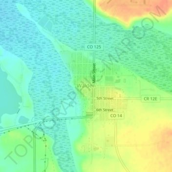
Nome: Mapa topográfico Walden, altitude, relevo.
Local: Walden, Jackson County, Colorado, United States (40.72605 -106.28693 40.73695 -106.27409)
Altitude média: 2.463 m
Altitude mínima: 2.447 m
Altitude máxima: 2.490 m
Faça uma doação
Outros mapas topográficos
Clique em um mapa para visualizar sua topografia, sua altitude e seu relevo.
Walden
United States > Colorado > Jackson County
Walden is the Statutory Town that is the county seat, the most populous community, and the only incorporated municipality in Jackson County, Colorado, United States. It is situated in the center of a large open valley called North Park. People from Walden and the surrounding area refer to themselves as "North…
Altitude média: 2.463 m
Faça uma doação