

Mapa topográfico Ishpatina Ridge
Clique no mapa para exibir a altitude.
Ishpatina Ridge
Ishpatina Ridge is the highest point of land in the Canadian province of Ontario, at an estimated 693 m (2,274 ft) above sea level. Ishpatina Ridge rises approximately 300 m (984 ft) above the immediate area. It was only truly recognized as Ontario's highest point after topographical mapping by the Government of Canada revealed this fact in the 1970s. Before then, the more popular Maple Mountain was thought to be higher.
Sobre este mapa
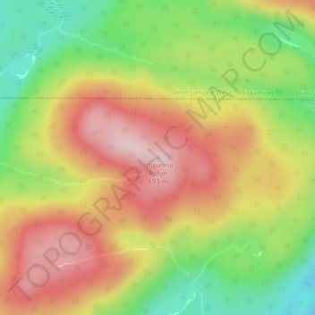
Nome: Mapa topográfico Ishpatina Ridge, altitude, relevo.
Altitude média: 545 m
Altitude mínima: 398 m
Altitude máxima: 679 m
Outros mapas topográficos
Clique em um mapa para visualizar sua topografia, sua altitude e seu relevo.
Tatachikapika Lake
Canada > Ontario > Sudbury District > Unorganized North Sudbury
Altitude média: 385 m
Mattagami Lake
Canada > Ontario > Sudbury District > Unorganized North Sudbury > Mattagami
Altitude média: 368 m
Chiniguchi River
Canada > Ontario > Sudbury District > Unorganized North Sudbury
Altitude média: 260 m
McLennan Creek;Moodie Lake
Canada > Ontario > Sudbury District > Unorganized North Sudbury
Altitude média: 456 m
Spanish River Provincial Park
Canada > Ontario > Sudbury District > Unorganized North Sudbury
Altitude média: 410 m


Sandcherry Creek
Canada > Ontario > Sudbury District > Unorganized North Sudbury
Altitude média: 423 m

West Shining Tree Lake
Canada > Ontario > Sudbury District > Unorganized North Sudbury > Shining Tree
Altitude média: 380 m
Whitefish River
Canada > Ontario > Sudbury District > Unorganized North Sudbury > Whitefish Falls
Altitude média: 195 m



Minisinakwa Lake
Canada > Ontario > Sudbury District > Unorganized North Sudbury > Gogama
Altitude média: 376 m