
Mapa topográfico Vladivostok
Mapa interativo
Clique no mapa para exibir a altitude.
Sobre este mapa
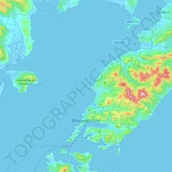
Nome: Mapa topográfico Vladivostok, altitude, relevo.
Altitude média: 29 m
Altitude mínima: -3 m
Altitude máxima: 450 m
Vladivostok has a monsoon-influenced humid continental climate (Köppen climate classification Dwb) with warm, humid and rainy summers and cold, dry winters. Owing to the influence of the Siberian High, winters are far colder than a latitude of 43 °N, roughly the same latitude as Milwaukee and Perpignan, should warrant given its low elevation and coastal location, with a January average of −11.9 °C (10.6 °F). Since the maritime influence is strong in summer, Vladivostok has a relatively cold annual climate for its latitude.