
Obrigado por apoiar este site ❤️
Faça uma doação
Faça uma doação
Mapa topográfico Galt
Clique no mapa para exibir a altitude.
Obrigado por apoiar este site ❤️
Faça uma doação
Faça uma doação
Sobre este mapa
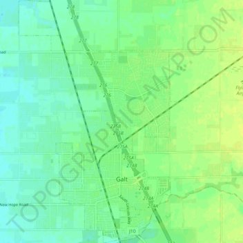
Nome: Mapa topográfico Galt, altitude, relevo.
Local: Galt, Sacramento County, California, 95632, United States (38.23632 -121.33764 38.30579 -121.28222)
Altitude média: 16 m
Altitude mínima: 8 m
Altitude máxima: 25 m
Obrigado por apoiar este site ❤️
Faça uma doação
Faça uma doação
Outros mapas topográficos
Clique em um mapa para visualizar sua topografia, sua altitude e seu relevo.
Obrigado por apoiar este site ❤️
Faça uma doação
Faça uma doação
Obrigado por apoiar este site ❤️
Faça uma doação
Faça uma doação
Obrigado por apoiar este site ❤️
Faça uma doação
Faça uma doação
Walnut Grove
United States > California > Sacramento County
Walnut Grove's location has made it the site of a rare collection of very tall radio and television transmission towers. The first major tower here was the KXTV/KOVR/KCRA Tower built in 1962, which dominated the skyline for over twenty years with its 1,548 foot height. In 1985 the old tower was joined by…
Altitude média: 1 m
Obrigado por apoiar este site ❤️
Faça uma doação
Faça uma doação
Obrigado por apoiar este site ❤️
Faça uma doação
Faça uma doação
Obrigado por apoiar este site ❤️
Faça uma doação
Faça uma doação
Obrigado por apoiar este site ❤️
Faça uma doação
Faça uma doação
Obrigado por apoiar este site ❤️
Faça uma doação
Faça uma doação
Obrigado por apoiar este site ❤️
Faça uma doação
Faça uma doação