
Obrigado por apoiar este site ❤️
Faça uma doação
Faça uma doação
Mapa topográfico Landican
Clique no mapa para exibir a altitude.
Obrigado por apoiar este site ❤️
Faça uma doação
Faça uma doação
Landican
Landican is in the central part of the Wirral Peninsula, approximately 6 km (3.7 mi) south-south-east of the Irish Sea at Leasowe Lighthouse, 5 km (3.1 mi) east-north-east of the Dee Estuary at Thurstaston and 5 km (3.1 mi) west-south-west of the River Mersey at Tranmere Oil Terminal. Landican is situated between Thurstaston Hill and the Bidston to Storeton ridge, with the centre of the hamlet at an elevation of about 44 m (144 ft) above sea level.
Obrigado por apoiar este site ❤️
Faça uma doação
Faça uma doação
Sobre este mapa
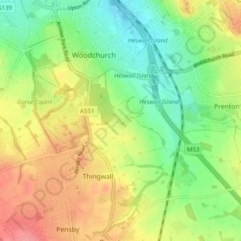
Nome: Mapa topográfico Landican, altitude, relevo.
Altitude média: 45 m
Altitude mínima: 10 m
Altitude máxima: 87 m
Obrigado por apoiar este site ❤️
Faça uma doação
Faça uma doação