
Mapa topográfico Schmißberg
Mapa interativo
Clique no mapa para exibir a altitude.
Sobre este mapa
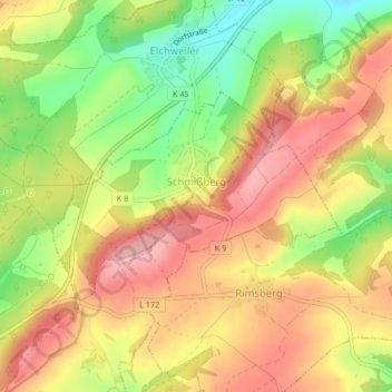
Nome: Mapa topográfico Schmißberg, altitude, relevo.
Altitude média: 432 m
Altitude mínima: 347 m
Altitude máxima: 498 m
Outros mapas topográficos
Clique em um mapa para visualizar sua topografia, sua altitude e seu relevo.
Ellenberg
Deutschland > Rheinland-Pfalz > Landkreis Birkenfeld
Ellenberg, Birkenfeld, Landkreis Birkenfeld, Rheinland-Pfalz, Deutschland
Altitude média: 469 m
Idar-Oberstein
Deutschland > Rheinland-Pfalz > Landkreis Birkenfeld
Idar-Oberstein, Landkreis Birkenfeld, Rheinland-Pfalz, 55743, Deutschland
Altitude média: 406 m
Hettenrodt
Deutschland > Rheinland-Pfalz > Landkreis Birkenfeld
Hettenrodt, Herrstein-Rhaunen, Landkreis Birkenfeld, Rheinland-Pfalz, Deutschland
Altitude média: 438 m
Bergen
Deutschland > Rheinland-Pfalz > Landkreis Birkenfeld
Bergen, Herrstein-Rhaunen, Landkreis Birkenfeld, Rheinland-Pfalz, 55608, Deutschland
Altitude média: 355 m
Herborn
Deutschland > Rheinland-Pfalz > Landkreis Birkenfeld > Herborn
Herborn, Herrstein-Rhaunen, Landkreis Birkenfeld, Rheinland-Pfalz, Deutschland
Altitude média: 465 m
Krummenau
Deutschland > Rheinland-Pfalz > Landkreis Birkenfeld > Krummenau
Krummenau, Herrstein-Rhaunen, Landkreis Birkenfeld, Rheinland-Pfalz, Deutschland
Altitude média: 456 m
Heimbach
Deutschland > Rheinland-Pfalz > Landkreis Birkenfeld
Heimbach, Baumholder, Landkreis Birkenfeld, Rheinland-Pfalz, 55779, Deutschland
Altitude média: 412 m