
Mapa topográfico Roseville
Clique no mapa para exibir a altitude.
Roseville
Roseville has a hot-summer Mediterranean climate that is characterized by cool, wet, usually snowless winters and hot, dry summers (Köppen Csa). The wet season is generally October through April. Because Roseville is east of Sacramento and at a higher elevation, it receives slightly more rainfall. Average daily high temperatures range from 53 °F (12 °C) in January to 94 °F (34 °C) in July. Daily low temperatures range from 39 °F (4 °C) in winter to 61 °F (16 °C) in summer.
Sobre este mapa
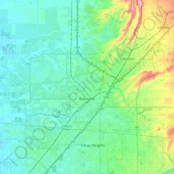
Nome: Mapa topográfico Roseville, altitude, relevo.
Local: Roseville, Placer County, California, United States (38.71635 -121.44670 38.82435 -121.18416)
Altitude média: 67 m
Altitude mínima: 17 m
Altitude máxima: 290 m
Outros mapas topográficos
Clique em um mapa para visualizar sua topografia, sua altitude e seu relevo.
Donner Peak
United States > California > Placer County
Donner Peak is an 8,019-foot-elevation (2,444-meter) summit in Placer County, California, United States.
Altitude média: 2.171 m
Carnelian Bay
United States > California > Placer County
For statistical purposes, the United States Census Bureau has defined Carnelian Bay as a census-designated place (CDP). The census definition of the area may not precisely correspond to local understanding of the area with the same name. The population was 524 at the 2010 census. The elevation is 6,325 feet…
Altitude média: 1.977 m
Blue Canyon
United States > California > Placer County
Blue Canyon (also, Blue Cañon) is an unincorporated community in Placer County, California. Blue Canyon is located 4 miles (6.4 km) southwest of Emigrant Gap. It lies at an elevation of 4695 feet (1431 m).
Altitude média: 1.452 m