
Mapa topográfico Whitemarsh Island
Mapa interativo
Clique no mapa para exibir a altitude.
Sobre este mapa
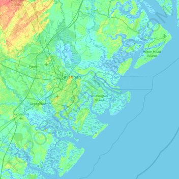
Nome: Mapa topográfico Whitemarsh Island, altitude, relevo.
Local: Whitemarsh Island, Chatham County, Georgia, 31410, USA (31.71271 -81.33428 32.35271 -80.69428)
Altitude média: 4 m
Altitude mínima: -6 m
Altitude máxima: 36 m
Outros mapas topográficos
Clique em um mapa para visualizar sua topografia, sua altitude e seu relevo.
Wilmington Island
Wilmington Island, Chatham County, Georgia, 31410, USA
Altitude média: 3 m
Arabia Mountain
USA > Georgia > Stonecrest
Arabia Mountain, Stonecrest, DeKalb County, Georgia, 30058-8829, USA
Altitude média: 255 m
Norwat Hill
USA > Georgia > Cusseta-Chattahoochee County
Norwat Hill, Cusseta-Chattahoochee County, Chattahoochee County, Georgia, USA
Altitude média: 83 m
Talahi Island
USA > Georgia > Talahi Island
Talahi Island, Chatham County, Georgia, 31410, USA
Altitude média: 4 m
Pleasant Grove
USA > Georgia > Pleasant Grove
Pleasant Grove, Catoosa County, Georgia, 30736, USA
Altitude média: 268 m
Coxs Crossing
USA > Georgia > Coxs Crossing
Coxs Crossing, Clayton County, Georgia, 30304, USA
Altitude média: 287 m
Grays Subdivision
USA > Georgia > Grays Subdivision
Grays Subdivision, Chatham County, Georgia, 31410, USA
Altitude média: 4 m
The Meadows North
USA > Georgia > The Meadows North
The Meadows North, Douglas County, Georgia, 30135, USA
Altitude média: 291 m
Sugar Creek
USA > Georgia > Sugar Creek
Sugar Creek, Douglas County, Georgia, 30135, USA
Altitude média: 336 m
Ferrell Crossroads
USA > Georgia > Ferrell Crossroads
Ferrell Crossroads, Early County, Georgia, USA
Altitude média: 94 m
Fort Oglethorpe
USA > Georgia > Fort Oglethorpe
Fort Oglethorpe, Catoosa County, Georgia, 30742, USA
Altitude média: 236 m
Fort Benning
USA > Georgia > Fort Benning
Fort Benning, Chattahoochee County, Georgia, 31905, USA
Altitude média: 95 m
Cameron Point
USA > Georgia > Cameron Point
Cameron Point, Hall County, Georgia, 30506:30534, USA
Altitude média: 339 m
safari park
USA > Georgia > Carrollton
safari park, Lamplighter Square, Carrollton, Carroll County, Georgia, USA
Altitude média: 321 m
Little White House Historic Site
Little White House Historic Site, Warm Springs Historic District, Meriwether County, Georgia, USA
Altitude média: 312 m