
Mapa topográfico Bad Salzuflen
Mapa interativo
Clique no mapa para exibir a altitude.
Sobre este mapa
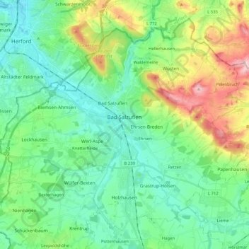
Nome: Mapa topográfico Bad Salzuflen, altitude, relevo.
Local: Bad Salzuflen, Kreis Lippe, North Rhine-Westphalia, Germany (52.01984 8.65323 52.12678 8.85657)
Altitude média: 120 m
Altitude mínima: 60 m
Altitude máxima: 278 m
Bad Salzuflen lies on the eastern edge of the Ravensberg Basin, at the confluence of the rivers Salze (Bega) with the Werre. In comparison to other North Lippe communities it is densely populated. The city centre is surrounded by districts with a village like feel to them and agricultural land. North east of the River Werre and Salze (Bega) runs a strand of the Lipper highlands runs through the largely wooded hills with elevations up to 250 meters in the city. The lowest point is on the border of the River Werre at Herford at about 70 meters. Since 2008, the city is part of the Teutoburg Forest Nature Park / Eggegebirge.
Outros mapas topográficos
Clique em um mapa para visualizar sua topografia, sua altitude e seu relevo.
Almena
Germany > North Rhine-Westphalia > Kreis Lippe > Almena
Almena, Extertal, Kreis Lippe, North Rhine-Westphalia, Germany
Altitude média: 160 m
Detmold
Germany > North Rhine-Westphalia > Kreis Lippe
Detmold, Kreis Lippe, North Rhine-Westphalia, Germany
Altitude média: 202 m