
Faça uma doação
Mapa topográfico Ixtapaluca
Clique no mapa para exibir a altitude.
Faça uma doação
Sobre este mapa
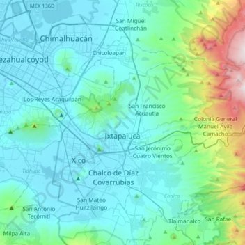
Nome: Mapa topográfico Ixtapaluca, altitude, relevo.
Local: Ixtapaluca, State of Mexico, Mexico (19.24687 -98.95393 19.41159 -98.63187)
Altitude média: 2.473 m
Altitude mínima: 2.223 m
Altitude máxima: 3.980 m
Faça uma doação
Outros mapas topográficos
Clique em um mapa para visualizar sua topografia, sua altitude e seu relevo.
Valle de Bravo
Mexico > State of Mexico > Valle de Bravo
The municipality is surrounded by mountain ranges and other elevated areas covering about 50% of the total area and include the Sierra de Temascaltepec, Sierra de Tenayac, Sierra de Valle de Bravos as wells as the hills that roll around the mountain ranges. These elevations include a number of small volcanoes…
Altitude média: 1.914 m
Faça uma doação
Faça uma doação
Texcoco de Mora
Mexico > State of Mexico > Texcoco
Tescoco lies about 25 km east of the centre of Mexico City. Major elevations in the municipality include the Tlaloc Mountain (4,500 meters) the Tetzcutzinco, Moyotepec and Tecuachacho. Most elevations are named after the major community to be found on them. There are also a number of small canyons. Part of the…
Altitude média: 2.448 m
Faça uma doação
Eje Neovolcánico
Mexico > State of Mexico > Amecameca
Volcanic ash make soils in the region very fertile, which (especially coupled with elevation making tropical climate milder) has led to high human population densities in the belt that now sometimes strain the environment.
Altitude média: 4.179 m
Faça uma doação
Santa Ana Jilotzingo
Mexico > State of Mexico > Jilotzingo > Santa Ana Jilotzingo
Altitude média: 2.760 m
Faça uma doação
San Lorenzo Tlalmimilolpan
Mexico > State of Mexico > Teotihuacán > San Lorenzo Tlalmimilolpan
Altitude média: 2.274 m
Faça uma doação
Santiago Tianguistenco
Mexico > State of Mexico > Tianguistenco
The municipality lies in the Trans-Mexican Volcanic Belt in the sub-province of the Lakes and Volcanoes of Anahuac. 35% of the municipality is mountainous, 30% is arable and the rest is developed. The topography of the municipality varies due to its size. The eastern portions are highest as they are in the…
Altitude média: 2.645 m