
Obrigado por apoiar este site ❤️
Faça uma doação
Faça uma doação
Mapa topográfico Sinnar
Clique no mapa para exibir a altitude.
Obrigado por apoiar este site ❤️
Faça uma doação
Faça uma doação
Sinnar
Sinnar is located at 19°51′N 74°00′E / 19.85°N 74.0°E / 19.85; 74.0. It has an average elevation of 651.4 metres (2135 feet). Sinnar is one of the major industrial zones of Malegaon (MIDC) built around the city of Nashik which have multiple international production companies. It lies 30 km southeast of Nashik city on the Pune - Nashik Highway.
Obrigado por apoiar este site ❤️
Faça uma doação
Faça uma doação
Sobre este mapa
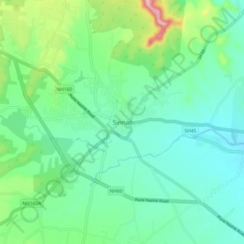
Nome: Mapa topográfico Sinnar, altitude, relevo.
Altitude média: 684 m
Altitude mínima: 631 m
Altitude máxima: 850 m
Obrigado por apoiar este site ❤️
Faça uma doação
Faça uma doação