
Faça uma doação
Mapa topográfico Padre Burgos
Clique no mapa para exibir a altitude.
Faça uma doação
Padre Burgos
On January 1, 1917, the village of Laguimanoc, which was formerly a barrio of Atimonan, became a municipality. On December 3, 1927, the town's name was changed to Padre Burgos by virtue of Act No. 3389, in honor of one of the country's martyrs, Fr. Jose Burgos. The streets were named after local leaders who rendered valuable services to the community. Because of the physical and topographic conditions of the town, four sitios where clusters of houses were became the main district of the town, namely: Campo, Burgos, Basiao and Bundok-Punta. The community converged to be in this particular spot because of its sea which made this town as port of Laguimanoc. In the early days this port offered a good wharf for vessels plying between Manila and southern Luzon. This was also a port of call for ships exporting lumber to Europe during the Spanish regime. In this town was the residence of the “Alcalde Mar” or Port Officer.
Faça uma doação
Sobre este mapa
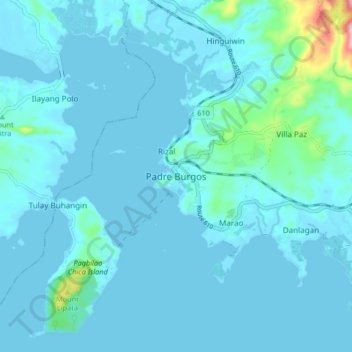
Nome: Mapa topográfico Padre Burgos, altitude, relevo.
Local: Padre Burgos, Quezon, Calabarzon, 4303, Philippines (13.87594 121.77495 13.95594 121.85495)
Altitude média: 19 m
Altitude mínima: -1 m
Altitude máxima: 236 m
Faça uma doação
Outros mapas topográficos
Clique em um mapa para visualizar sua topografia, sua altitude e seu relevo.
Sariaya
Sariaya is situated on a flat land except for a portion on the north occupying a part of the foot of Mount Banahaw. The municipality has the highest point of elevation on 3,800 feet above sea level at Barangays Concepcion Banahaw and Sampaloc Bogon.
Altitude média: 117 m
Faça uma doação
Faça uma doação
Faça uma doação
Faça uma doação
Faça uma doação
Faça uma doação
Faça uma doação
Faça uma doação
Faça uma doação
Faça uma doação
Faça uma doação
Laguna-Quezon Land Grant Lagoon
Philippines > Quezon > Real > Magsaysay > Maunlad
Altitude média: 389 m
Faça uma doação
Faça uma doação
Faça uma doação
Faça uma doação
Sariaya
Sariaya is situated on a flat land except for a portion on the north occupying a part of the foot of Mount Banahaw. The municipality has the highest point of elevation on 3,800 feet (1,200 m) above sea level at Barangays Concepcion Banahaw and Sampaloc Bogon.
Altitude média: 117 m
Faça uma doação
Faça uma doação
Faça uma doação
Faça uma doação
Faça uma doação