
Faça uma doação
Mapa topográfico Kazabazua
Clique no mapa para exibir a altitude.
Faça uma doação
Kazabazua
The village and municipality are named after the Kazabazua River which passes through it. Like many other First Nations names, Kazabazua has had many spellings in English, such as Kazaluzu, Kasubasua, Cazabasua, Cazibazouis, Cazebalzuac, Cajibajouis. This word comes from the Algonquin word kachibadjiwan, from kach ("hidden") and djiwan ("current"), hence it means "underground river". This name is a reflection of the local topography because the Kazabazua River disappears underground and resurfaces a few dozen metres (yards) downstream. The river then flows through rapids and passes under a natural stone bridge.
Faça uma doação
Sobre este mapa
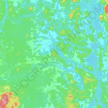
Nome: Mapa topográfico Kazabazua, altitude, relevo.
Altitude média: 178 m
Altitude mínima: 138 m
Altitude máxima: 359 m
Faça uma doação
Outros mapas topográficos
Clique em um mapa para visualizar sua topografia, sua altitude e seu relevo.
Île Laflamme
Canada > Quebec > La Vallée-de-la-Gatineau > Sainte-Thérèse-de-la-Gatineau
Altitude média: 248 m
Faça uma doação
Faça uma doação
Sainte-Thérèse-de-Gatineau
Canada > Quebec > La Vallée-de-la-Gatineau > Sainte-Thérèse-de-la-Gatineau
Altitude média: 180 m
Faça uma doação
Faça uma doação