
Mapa topográfico Center Point
Mapa interativo
Clique no mapa para exibir a altitude.
Sobre este mapa
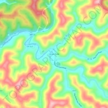
Nome: Mapa topográfico Center Point, altitude, relevo.
Altitude média: 312 m
Altitude mínima: 229 m
Altitude máxima: 403 m
Center Point is an unincorporated community in northeastern Doddridge County, West Virginia, USA. It lies along Route 23 northeast of the town of West Union, the county seat of Doddridge County. Its elevation is 791 feet (241 m).
Outros mapas topográficos
Clique em um mapa para visualizar sua topografia, sua altitude e seu relevo.
Talkington Fork McElroy Creek
United States > West Virginia > Center Point
Talkington Fork McElroy Creek, Center Point, Doddridge County, West Virginia, 26339, United States
Altitude média: 300 m