
Obrigado por apoiar este site ❤️
Faça uma doação
Faça uma doação
Mapa topográfico Enniskillen
Clique no mapa para exibir a altitude.
Obrigado por apoiar este site ❤️
Faça uma doação
Faça uma doação
Sobre este mapa
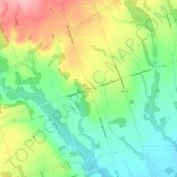
Nome: Mapa topográfico Enniskillen, altitude, relevo.
Altitude média: 242 m
Altitude mínima: 187 m
Altitude máxima: 320 m
Obrigado por apoiar este site ❤️
Faça uma doação
Faça uma doação
Outros mapas topográficos
Clique em um mapa para visualizar sua topografia, sua altitude e seu relevo.
Darlington Provincial Park
Canada > Ontario > Durham Region > Clarington
Darlington Provincial Park is a provincial park in Ontario, Canada. It is located just south of Highway 401 in the city of Bowmanville. A small park, the topography is dominated by gentle hills formed by a terminal moraine deposited by glaciers at the end of the last Ice Age. The park borders on the northern…
Altitude média: 84 m