
Mapa topográfico Coldwater
Mapa interativo
Clique no mapa para exibir a altitude.
Sobre este mapa
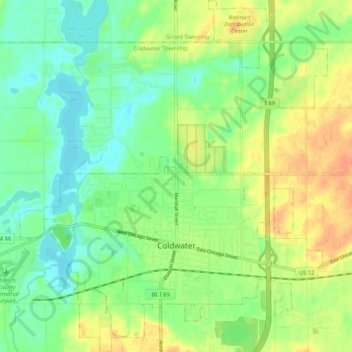
Nome: Mapa topográfico Coldwater, altitude, relevo.
Local: Coldwater, Branch County, Michigan, United States of America (41.91658 -85.04757 41.99473 -84.95543)
Altitude média: 296 m
Altitude mínima: 279 m
Altitude máxima: 318 m
Coldwater is at 41°56′25″N 85°00′02″W / 41.94028°N 85.00056°W / 41.94028; -85.00056. The ZIP code is 49036 and the FIPS place code is 17020. The elevation is 969 feet (295 m) above sea level. The City of Coldwater is entirely surrounded by the Township of Coldwater.