
Obrigado por apoiar este site ❤️
Faça uma doação
Faça uma doação
Mapa topográfico Dawis
Clique no mapa para exibir a altitude.
Obrigado por apoiar este site ❤️
Faça uma doação
Faça uma doação
Sobre este mapa
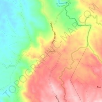
Nome: Mapa topográfico Dawis, altitude, relevo.
Local: Dawis, Negros Oriental, Central Visayas, Philippines (9.55667 122.86191 9.59667 122.90191)
Altitude média: 276 m
Altitude mínima: 161 m
Altitude máxima: 385 m
Obrigado por apoiar este site ❤️
Faça uma doação
Faça uma doação
Outros mapas topográficos
Clique em um mapa para visualizar sua topografia, sua altitude e seu relevo.
Dumaguete
As a coastal city, it is bounded on the east by the Bohol Sea and the Tañon Strait, serving as a natural border of southeastern Negros Island Region to the neighboring Central Visayas. The city's topography is generally flat from two to six kilometers from the shoreline. It slopes gently upwards to the…
Altitude média: 55 m
Obrigado por apoiar este site ❤️
Faça uma doação
Faça uma doação