Mapa topográfico Thornton Reservoir
Clique no mapa para exibir a altitude.
Sobre este mapa
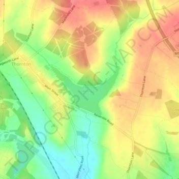
Nome: Mapa topográfico Thornton Reservoir, altitude, relevo.
Altitude média: 139 m
Altitude mínima: 103 m
Altitude máxima: 168 m

Clique no mapa para exibir a altitude.
Nome: Mapa topográfico Thornton Reservoir, altitude, relevo.
Altitude média: 139 m
Altitude mínima: 103 m
Altitude máxima: 168 m