
Obrigado por apoiar este site ❤️
Faça uma doação
Faça uma doação
Mapa topográfico Garstang
Clique no mapa para exibir a altitude.
Obrigado por apoiar este site ❤️
Faça uma doação
Faça uma doação
Sobre este mapa
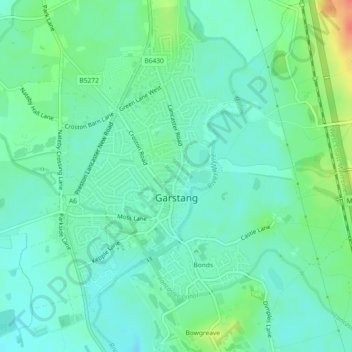
Nome: Mapa topográfico Garstang, altitude, relevo.
Local: Garstang, Borough of Wyre, Lancashire, England, United Kingdom (53.89262 -2.79394 53.91382 -2.76443)
Altitude média: 24 m
Altitude mínima: 10 m
Altitude máxima: 59 m
Obrigado por apoiar este site ❤️
Faça uma doação
Faça uma doação
Outros mapas topográficos
Clique em um mapa para visualizar sua topografia, sua altitude e seu relevo.