
Obrigado por apoiar este site ❤️
Faça uma doação
Faça uma doação
Mapa topográfico Pedrógão
Clique no mapa para exibir a altitude.
Obrigado por apoiar este site ❤️
Faça uma doação
Faça uma doação
Sobre este mapa
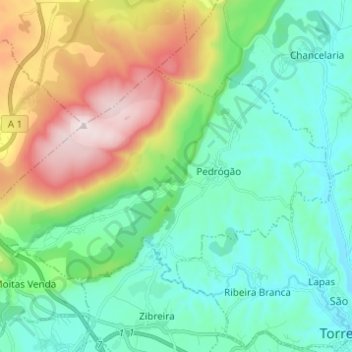
Nome: Mapa topográfico Pedrógão, altitude, relevo.
Local: Pedrógão, Torres Novas, Santarém, 2350-228, Portugal (39.49313 -8.67332 39.55071 -8.55043)
Altitude média: 189 m
Altitude mínima: 27 m
Altitude máxima: 679 m
Obrigado por apoiar este site ❤️
Faça uma doação
Faça uma doação
Outros mapas topográficos
Clique em um mapa para visualizar sua topografia, sua altitude e seu relevo.
Obrigado por apoiar este site ❤️
Faça uma doação
Faça uma doação
Monumento Natural das Pegadas de Dinossáurios de Ourém/Torres Novas
Portugal > Santarém > Torres Novas > Chancelaria
Altitude média: 289 m
Obrigado por apoiar este site ❤️
Faça uma doação
Faça uma doação
Obrigado por apoiar este site ❤️
Faça uma doação
Faça uma doação